


RS-Le Garboud

raymondfn
User
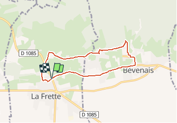

Length
6.9 km

Max alt
531 m

Uphill gradient
134 m
Km-Effort
8.6 km

Min alt
427 m

Downhill gradient
133 m
Boucle
Yes
Creation date :
2019-09-18 09:25:19.818
Updated on :
2020-12-29 15:40:36.36
1h14
Difficulty : Easy

FREE GPS app for hiking
 SityTrail
IGN / Geographical institutes
SityTrail Plus
The world is yours!
About
Trail Walking of 6.9 km to be discovered at Auvergne-Rhône-Alpes, Isère, La Frette. This trail is proposed by raymondfn.
Description
Rando Santé - La Frette
Positioning
Country:
France
Region :
Auvergne-Rhône-Alpes
Department/Province :
Isère
Municipality :
La Frette
Location:
Unknown
Start:(Dec)
Start:(UTM)
684787 ; 5029355 (31T) N.
Comments